🎉 Up to 70% Off Selected ItemsShop Sale
SXS Trail Sisters to Camp Sherman loop trail
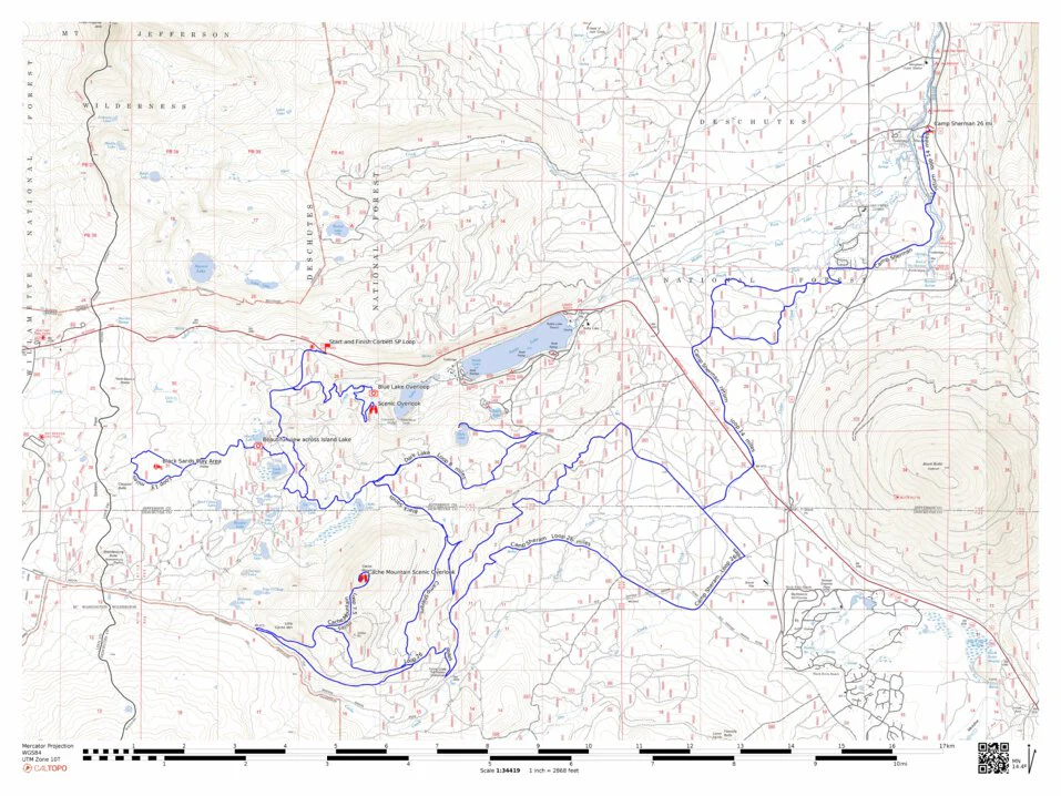
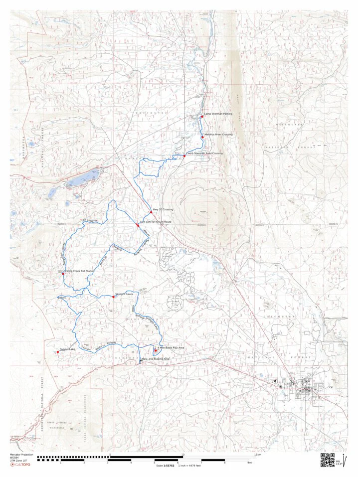
This is a great spring trail, start at Hwy, 242 Staging area about 8 miles east of Sisters and ride to Camp Sherman for lunch. SxS are not allowed in Camp Sherman so will to park about 300 yds out of town. You will see Skylight Caves, the historic Cache Creek Toll Station, do some hill climbing at 4 Mile Butte and visit the headwaters of the Metolius River. The total route is approx 65 miles. Bring a camera. Trial length approx. 63 miles.
This map is presented for public use as-is, with no guarantee of accuracy or completeness. The geographic information contained on this site is not to be construed or used as a "true description". Every effort has been made to ensure the map accuracy, but errors in mapping or errors in the source documents do occur. Oregon SxS Trail Coalition assumes no liability for either any errors, omissions, or inaccuracies in the information provided regardless of their cause, or for any decision made, action taken, or action not taken by the user in reliance upon any maps or information provided. These maps are for information purposes only and may not represent actual conditions
Product Information
Product Information
Shipping & Returns
Shipping & Returns

SXS Trail Sisters to Camp Sherman loop trail
SXS Trail Sisters to Camp Sherman loop trail
This is a great spring trail, start at Hwy, 242 Staging area about 8 miles east of Sisters and ride to Camp Sherman for lunch. SxS are not allowed in Camp Sherman so will to park about 300 yds out of town. You will see Skylight Caves, the historic Cache Creek Toll Station, do some hill climbing at 4 Mile Butte and visit the headwaters of the Metolius River. The total route is approx 65 miles. Bring a camera. Trial length approx. 63 miles.
This map is presented for public use as-is, with no guarantee of accuracy or completeness. The geographic information contained on this site is not to be construed or used as a "true description". Every effort has been made to ensure the map accuracy, but errors in mapping or errors in the source documents do occur. Oregon SxS Trail Coalition assumes no liability for either any errors, omissions, or inaccuracies in the information provided regardless of their cause, or for any decision made, action taken, or action not taken by the user in reliance upon any maps or information provided. These maps are for information purposes only and may not represent actual conditions
$4.99
SXS Trail Sisters to Camp Sherman loop trail—
$4.99
Product Information
Product Information
Shipping & Returns
Shipping & Returns
Description
This is a great spring trail, start at Hwy, 242 Staging area about 8 miles east of Sisters and ride to Camp Sherman for lunch. SxS are not allowed in Camp Sherman so will to park about 300 yds out of town. You will see Skylight Caves, the historic Cache Creek Toll Station, do some hill climbing at 4 Mile Butte and visit the headwaters of the Metolius River. The total route is approx 65 miles. Bring a camera. Trial length approx. 63 miles.
This map is presented for public use as-is, with no guarantee of accuracy or completeness. The geographic information contained on this site is not to be construed or used as a "true description". Every effort has been made to ensure the map accuracy, but errors in mapping or errors in the source documents do occur. Oregon SxS Trail Coalition assumes no liability for either any errors, omissions, or inaccuracies in the information provided regardless of their cause, or for any decision made, action taken, or action not taken by the user in reliance upon any maps or information provided. These maps are for information purposes only and may not represent actual conditions